Neighborhood Considerations
Potential effects on surrounding neighborhoods, based on the scope described in the applicant's own filing.
The Site: Current vs. Proposed
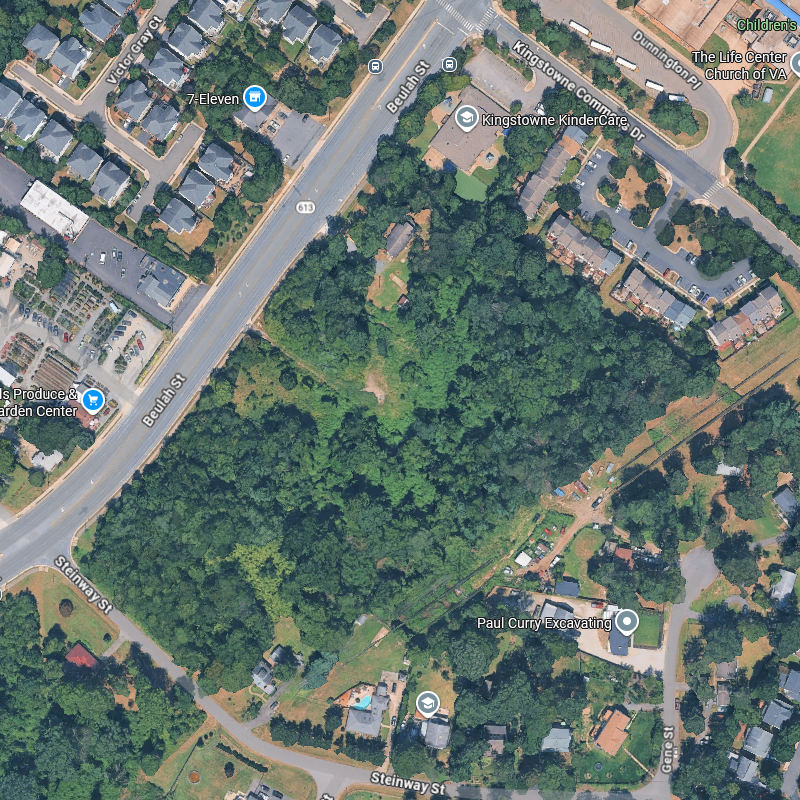
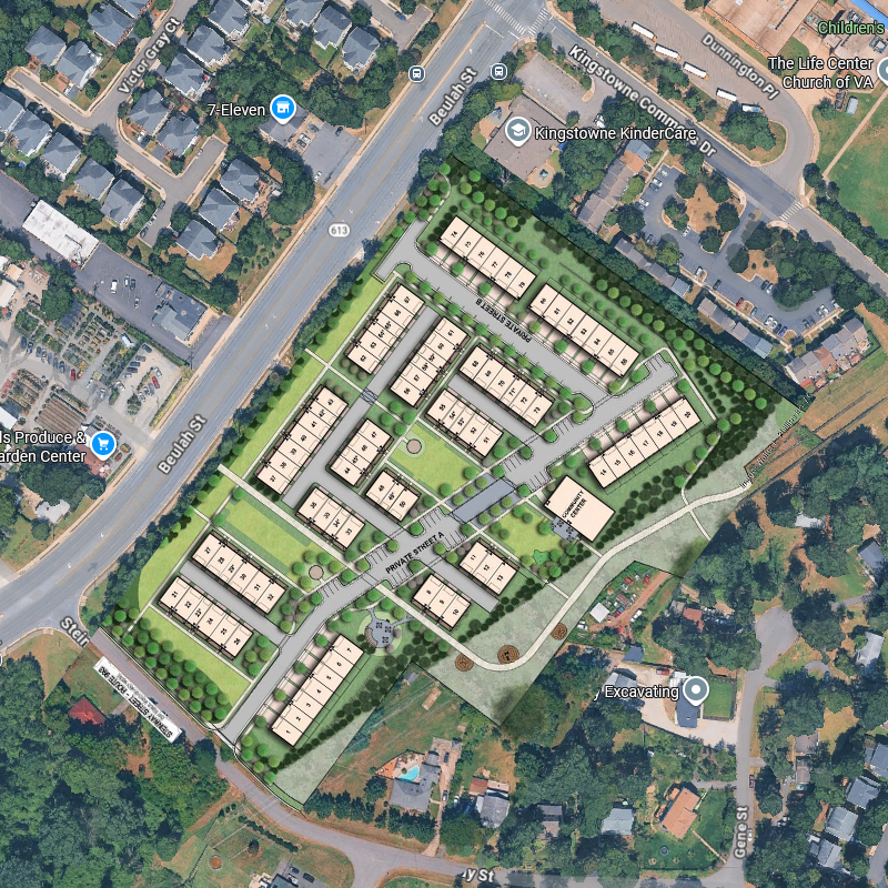
Satellite imagery via Google Maps. Proposed overlay from applicant site plan rendering.
Construction
The proposed scope — 76 units, private streets, underground stormwater facilities, structured utilities, multi-story construction — would reasonably require construction activity over multiple years.
Residents on Steinway Street, in the Kingstowne community along Kingstowne Commons Drive, and in the Queens Court and Winford neighborhoods would be most directly affected.
Traffic and Access
The June 16, 2026 revision relocated all vehicle access to a single new entrance on Beulah Street, approximately 475 feet north of Steinway Street. Earlier versions of the application proposed access from Steinway Street.
Beulah Street is a five-lane minor arterial (Route 613) with a posted speed of 35 miles per hour. At Steinway Street, Steinway is stop-controlled and Beulah Street traffic does not stop; there is no marked crosswalk or pedestrian signal at that intersection. The nearest signalized crossing of Beulah Street is at Kingstowne Commons Drive. The plat records available sight distance at the proposed entrance of 440 feet to the left and 465 feet to the right; it does not state a design speed or the required sight distance for comparison.
The county issued a Tier 1 transportation determination on November 25, 2025. That determination was made for 86 units with access from Steinway Street, before the entrance was relocated. Even age-restricted communities generate traffic beyond typical commute patterns — medical appointments, deliveries, and visitor peaks throughout the day. The proposed 24/7 operation means activity is not limited to business hours.
Source: Transportation Statement, revised June 16, 2026; Special Exception Plat sheet P-0603; FCDOT Transportation Study Determination, Nov. 25, 2025.
Privacy and Scale
The application proposes townhome-style units of up to three stories and approximately 44 feet, and detached-style units of up to 35 feet. Note 17 on the plat has not been updated from the original filing and still states a maximum of 50 feet and 4 stories.
For comparison, the two existing homes on the site are recorded on the applicant’s own existing conditions sheet as one story and one and a half stories, each approximately 20 feet in height, built in 1954 and 1955. The county’s own plan amendment summary describes the residences immediately to the south, on Steinway Street, as single-family homes on 0.5 acre lots. Winford consists of stand-alone single-family homes, and Queens Court to the north consists of two- to three-story townhomes developed at 3–4 dwelling units per acre.
The application seeks relief from the required barrier along the southern property line, citing the 100-foot wide VEPCO transmission easement along that boundary.
Source: Special Exception Plat sheets P-0102, P-0201 and P-0402, June 16, 2026; Statement of Justification, June 16, 2026.
Tree Canopy and Wildlife
The applicant's own vegetation mapping records approximately 334,707 square feet of upland forest, roughly 7.7 acres of the 10.97-acre site. This mature canopy provides privacy screening, wildlife habitat (deer, fox, rabbits, monarch butterflies, hawks, bats, an occasional eagle, and various bird species are commonly observed), natural stormwater absorption, and the wooded character that drew many residents to this area.
The plat records a tree preservation target of 100,868 square feet and states that 10.3% of that target would be met, with a deviation requested. The post-development sheet records 0.00 acres of forest or open space remaining.
Neighbors are encouraged to document local wildlife sightings to help establish what currently lives in and around this habitat.
Source: Special Exception Plat sheets P-0203, P-0204 and P-0504, June 16, 2026.
Stormwater
Converting a largely forested 10.97-acre site to buildings, private streets, and paved surfaces fundamentally changes how stormwater moves through the area. Forested soil absorbs rainfall naturally; impervious surfaces redirect it as runoff.
The applicant's own plan sheets record impervious cover increasing from approximately 0.51 acres before development to approximately 5.38 acres after, or roughly 5% to 49% of the site.
The application references underground stormwater facilities. Their adequacy and effect on neighboring properties will be evaluated during the county review. Neighbors downstream of the site should monitor this closely.
Source: Special Exception Plat sheets P-0503 and P-0504, June 16, 2026.
Utilities and Infrastructure
A county notice dated February 9, 2026 indicates that the property currently relies on a well and/or septic system. Transitioning to public water and sewer to support 76 units would require utility extension, associated construction, and coordination with Fairfax Water and the Department of Public Works. This introduces additional environmental disturbance and infrastructure impacts beyond those of the buildings themselves.
Source: PLUS Record SE-2025-FR-00044, Condition Notice, 02/09/2026.
Density
The Comprehensive Plan recommends this site for residential use at 1–2 dwelling units per acre. The application proposes 76 units on approximately 10.97 acres, a density of approximately 6.93 dwelling units per acre.
The Zoning Ordinance allows the planned density for an independent living facility to be increased by a multiplier where a special exception is approved. Separately, a county zoning determination dated March 18, 2025 found that the subdivision containing these parcels is already nonconforming as to density, and that removing the parcels would increase the density of the remainder.
Source: Special Exception Plat sheet P-0102, June 16, 2026; County zoning determination, March 18, 2025.
Cumulative Impact
This proposal does not exist in isolation. Other pending applications, rezonings, and site plans in the surrounding area may compound effects on traffic, infrastructure, and neighborhood character. The cumulative impact is a reasonable consideration for the county's review.
Track active applications: Fairfax County PLUS
A Note on Perspective
These considerations are based on the applicant's filings and publicly available county records — factual observations, not conclusions. The county review process exists to evaluate these factors. Neighbors are encouraged to engage constructively in that process.